17/8/09

Google Maps' Arunachal Pradesh placenames now back to normal

vía Ogle Earth de stefan.geens@gmail.com el 10/08/09

Live proof on maps.google.com that the place names in Arunachal Pradesh have now been restored to their previous, non-controversial selves:


View Larger Map

That dotted line is India's claim line. To the north lies China with Chinese placenames. To the South, Arunachal Pradesh, now with Chinese placenames removed. (To the west, Bhutan.)

Don't know what all this is about? Read up here.

While we're at it, here is the same view in maps.google.co.in, wherein we see the only legal world view allowed in India:


View Larger Map

Meanwhile, China's decreed world view remains unperturbed on ditu.google.cn:


查看大图

Decreeing reality must be so much fun. At least until it leads to war. I'm glad that there is a proper reference map for the rest of us.


Google Maps' Arunachal Pradesh place names turn Chinese, Google admits error

vía Ogle Earth de stefan.geens@gmail.com el 9/08/09

[Update 2009-09-10: Aruchanal Pradesh's placenames are now back to normal in Google Maps.]

China and India are two of the globe's most touchy countries when it comes to how their borders are depicted on unofficial maps — in fact, in both countries it is illegal to publish maps where the borders deviate from official "guidance". This makes the border between India and China quite interesting, especially as large chunks of it are disputed.

There is a pleasing symmetry to these disputes: In the west, Aksai Chin is claimed by India but administered by China. To the east, most of Arunachal Pradesh is claimed by China but administered by India. These are huge territories, so you might think there is plenty of room for a negotiated compromise — and you'd be right; just this Friday China and India sat down for yet another round of talks — their thirteenth, in fact. Differences are "narrowing", according to Reuters.

In the past few days, Ogle Earth began receiving a surge of Google Search-referred visits from Indian IP addresses to older posts about Arunachal Pradesh, mostly on variations of searches for "Arunachal Pradesh Google". Google had previously made an error regarding that region's disputed border in Google Earth, but had fixed it quickly. Has Google now messed up again, at a particularly sensitive moment in time?

In a word, Yes. Indian bloggers and media this past Thursday noticed that many place names in Arunachal Pradesh had turned Chinese in Google Maps, depicted both in Chinese characters and their Anglicized equivalent. For example: Around Tawang, home to the famous Buddhist monastery near the Bhutanese border, place names are now written like this:

oopsap2tawang.png

All place names north of China's claim line are depicted thus. Place names to the South are mostly in Hindi, with an Anglicized equivalent:

oopsap1.jpg

Those are indeed aberrant depictions of place names, if Google intends to be neutral about a region administered by India but claimed by China. (Place names in Aksai Chin are in Chinese, for example.) And sure enough, Indian bloggers, reporters and even politicians were not particularly inclined to give Google the benefit of the doubt, not 24 hours before the start of those "high-stakes" border talks. Times of India quotes one MP:

''This is shocking. How could Google change the names of places of a sovereign country without the country's knowledge?'' fumed Congress's West Arunachal MP Takam Sanjoy.

Etc.

But then Google reacted. To their credit, they quickly admitted to a mistake in a statement released to the media and republished by many Indian media sites on Saturday:

Earlier this week, as part of a routine update to Google Earth, we published new data for the Arunachal Pradesh region that changed the depiction of certain place names in the product. The change was a result of a mistake in our processing of new map data. We are in the process of reverting the data to its previous state, and expect the change to be visible in the product shortly. We would like to clarify that this issue did not impact our depiction of international borders.

(A quick fact check: It wasn't place names in Google Earth that were affected — they still depict only Anglicized versions of Hindi names. It's in Google Maps that the error occurred. Google Earth does show some user-generated Panoramio photo icon labels in Chinese in Arunachal Pradesh, but there is nothing wrong with Panoramio users writing in their own language.)

Someone identifying themselves as an employee of Perfect Relations, India's self-described largest PR firm, even posted the above statement "on behalf" of Google in the comments section of one of the Ogle Earth posts currently receiving all that Google Search traffic. This seems to be a new strategy, aimed at quickly quenching any budding outrage in the (Indian) blogosphere, by taking the conversation to the blogs themselves.

Now it is just a matter of waiting until the names are corrected. But will that end the outrage? The problem is that when those Indian bloggers and journalists went looking on Google Maps, they also noticed that both the Indian and Chinese claim lines for Arunachal Pradesh are drawn in dotted lines. Neither is given the prominence of a national border, and Google does not play favorites, just as it doesn't with Aksai Chin, where borders are also drawn in dotted lines.

In Google Earth, disputed national boundaries are perhaps even more clearly demarcated, as a red line instead of a yellow line, and annotated as well:

chinaclaim.jpg

indiaclaim.jpg

This is, of course, as it should be. National borders in Google Earth that are not bilaterally agreed to are in red, no matter how tenuous the claim. Good luck telling that to the rabid fringe among India's bloggers though — and I'm pretty sure that is why Google's statement contains the preëmptively plaintive line, "We would like to clarify that this issue did not impact our depiction of international borders."

Google's policy regarding disputed borders has, however, progressed since late 2007, when it last made a cartographical error in the region. Here is how Arunachal Pradesh's border looked when Google made that mistake in early November 2007:

apge.jpg

And here it is after it was corrected, in November 2007:

Indiacorrect.jpg

For at least the last few months, however, Google has been showing both claim lines:

apge2009.jpg

Additionally, "lines of control", such as the one between India and Pakistan in Kashmir, are in orange. I approve, because I am for more information, not less. Even if you don't agree with the validity of a certain claim line or de facto control line, you should at least want to know where that line is. Maps that don't depict such information for political reasons do their users a great disservice.

And Google can't be faulted for not trying to bring as much nuance and context as possible to its maps. Here is the popup box for the main place name of Arunachal Pradesh in Google Earth:

googlecontextap.jpg

One final question: How might an error like this have happened? Google in fact maintains two sets of Google Maps databases: One for the proper internet, and one for users in China. This latter map does depict Arunachal Pradesh as being integral to China, and with identical Chinese names as the one that accidentally populated the global Google Maps. (For example, Tawang on ditu.google.cn vs Tawang on maps.google.com).

The reason for the Chinese Google Maps is simple — Google serves them from Chinese servers, which are subject to Chinese law, and it would be illegal for Google's Chinese business unit to depict Arunachal Pradesh in any other way. And somehow, data intended for the China map must have ended up in the global map. (It would be interesting to know how:-)

Could India demand a Google Maps for Indian users that depicts the world's borders as India's government decrees them? Google Maps isn't served from inside India, because India doesn't indulge in anything as offensive as censorious China's great firewall, so the short answer is No, unless India's politicians were to change the law and start making life difficult for Google's Indian business units. [Update 14:47 UTC: Scrap that. maps.google.co.in shows both Aksai Chin and Arunachal Pradesh as being integral to India. I guess that map is served from inside India and/or Indian politicians have already gotten their way. But on the Indian Google Map, too, placenames are Chinese both in Arunachal Pradesh and Aksai Chin.]

(Just to be clear: You can currently access maps.google.com and Google Earth from China, but only at the pleasure of China's censors, and with a performance hit due to the great bottleneck that is the great firewall.)
5/7/09

ENDONIMO Y EXONIMO


El Glosario de términos para la normalización de los nombres geográficos fue elaborado por el Grupo de Trabajo sobre Terminología Toponímica del Grupo de Expertos de las Naciones Unidas en Nombres Geográficos, y su primera edición fue publicada en 2002 por el Departamento de Asuntos Económicos y Sociales de la Secretaría de las Naciones Unidas.

La Octava Conferencia de las Naciones Unidas sobre la Normalización de los Nombres Geográficos, celebrada en Berlín del 27 de agosto al 5 de septiembre de 2002, recomendó, en su resolución VIII/3, que el Grupo de Trabajo sobre Terminología continuara trabajando con objeto de examinar periódicamente el Glosario y actualizarlo según fuera necesario.

En la Novena Conferencia de las Naciones Unidas sobre la Normalización de
los Nombres Geográficos, celebrada en Nueva York del 21 al 30 de agosto de 2007, se ratificaron los términos que se indican a continuación y se aprobó la inclusión de los mismos en el Glosario.


EXÓNIMO Nombre usual en una lengua para designar un accidente geográfico situado fuera del área donde se habla mayoritariamente aquella lengua y que difiere en su forma del/de los endónimo(s) del área donde el accidente
geográfico está situado.
ENDÓNIMO Nombre de un accidente geográfico en una lengua oficial o en una de las lenguas utilizadas en la región en la que se localiza el accidente.

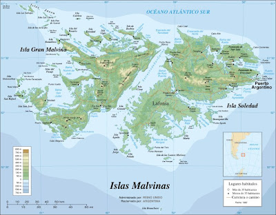
Fuente: Toponimia de las Islas Malvinas

(De:
El mundo de los mapas, 30/06/08)

30/6/09

GeoTree, herramienta de Geonames


Los desarrolladores de Geonames.org han liberado una nueva herramienta para consultar su base de datos: GeoTree, la cual permite mostrar en un árbol jerárquico (treeview) su base de datos de toponimia del mundo.

De esta manera puedes ver las unidades administrativas partiendo de cualquier continente para entrar a cada uno de los países de la región, mostrandose la bandera, el nombre y en el caso de Fracia el escudo de armas de la región (usando la información del proyecto blason de la wikipedia francesa).

También puedes indicar por medio de la url un subconjunto o la búsqueda de elementos específicos, por ejemplo las playas de España.

Visto en el blog de geonames.org

29/6/09

Mapas con sonidos, topónimos con acento

He pasado un rato divertido jugando con Sons de Barcelona, una web construida sobre Google Maps donde se pueden oir todo tipo de sonidos de la ciudad catalana, desde el ruido de la calle desde un cuarto piso al paso de una manifestación hasta el sonido captado por un micrófono arrastrado por la arena de la playa. Se trata de una iniciativa enmarcada dentro del proyecto freesound, una iniciativa de tipo colaborativo que está construyendo un banco de datos de sonidos, que no canciones, con licencia Creative Commons. La página Sons de Barcelona ha sido puesta en marcha por el Grup de Recerca en Tecnologia Musical (MTG) de la Universitat Pompeu Fabra. Permite subir sonidos tras registrarse y rellenar una ficha. Además, proponen utilizar esta herramienta para realizar diferentes tipos de talleres (describen tres) relacionados con el sonido ambiental urbano.


La idea de mapas con sonidos es seductora. Me imagino, por ejemplo, que la toponimia fuera audible. Cada vez existe mayor interés en que los nomenclátores oficiales tengan la transcripción fonética de los nombres geográficos, pues tan normalizada es la grafía y la posición del topónimo como su pronunciación. ¿Qué mejor, pues, que oirlo? Yendo más allá, también sería un ejercicio interesante el que el público pudiera añadir registros sonoros con su versión, con su forma de pronunciar un topónimo dado, ampliando la gama de acentos y variantes más allá de la "oficial". De hecho, sería una gran ayuda por si alguien se plantea realizar búsquedas geográficas mediante la voz... Habrá que comentarlo en la próxima Jornada de la CENG.

Publicado por Joan Capdevila

(Tomado de: Blog IDEE)


II Jornada de la Comisión Especializada de Nombres Geográficos


II JORNADA DE LA COMISIÓN ESPECIALIZADA DE NOMBRES GEOGRÁFICOS.

El día 24 de marzo de 2009 se celebró en el Paraninfo de la Universidad Complutense de Madrid la II Jornada de la Comisión Especializada de Nombres Geográficos, con el título «La importancia del uso normalizado de la toponimia».
En el acto de presentación de la II Jornada intervinieron D. Dámaso López García, Decano de la Facultad de Filología de la Universidad Complutense de Madrid; D. Alberto Sereno Álvarez, Director General del Instituto Geográfico Nacional y Vicepresidente del Consejo Superior Geográfico; D. Rafael Martín de Agar, Presidente de la Comisión Especializada de Nombres Geográficos (CENG); D. Fernando Lázaro Mora, Director del Departamento de Lengua Española y Teoría de la Literatura Comparada y D. Manuel Alvar Ezquerra, Presidente del Comité Organizador.
A lo largo de la Jornada se expusieron ponencias correspondientes al ámbito europeo: «El Grupo de Trabajo Técnico sobre nombres geográficos (TWG-GN) de INSPIRE» expuesta por D. Miquel Parella i Codina (Institut Cartogràfic de Catalunya); al ámbito estatal: «Nomenclátor Geográfico Nacional: Nomenclátor Geográfico Básico y Nomenclátores de las CCAA» a cargo de D. Antonio Luján Díaz, D.a Marta Montilla Lillo (Instituto Geográfico Nacional) y D. Antonio Vázquez
Hoehne (Universidad Politécnica de Madrid); y de carácter más general: «La toponimia en los medios de comunicación españoles en castellano con especial atención a los libros de estilo» por parte de D. Jairo Javier García Sánchez (Universidad de Alcalá de Henares) y «Toponimia y Geografía» de D. Fernando
Arroyo Llera (Universidad Autónoma de Madrid).
Así mismo se puso de manifiesto la labor llevada a cabo en materia de toponimia por las Comunidades Autónomas, a través de las ponencias «La toponimia en la Comunidad Autónoma de Andalucía» expuesta por D.a M.a Teresa Garrido Borrego (Instituto Cartográfico de Andalucía); «La toponimia en la Comunidad Autónoma de Canarias: contribuciones y proyectos» expuesta por D.a Carmen Díaz Ayllón (Universidad de La Laguna); «Recopilación y representación de la Toponimia en Castilla y León» a cargo de D. Hermógenes Perdiguero (Universidad de Burgos) y «La toponimia en la Comunidad Foral de Navarra» por Xabier Aranza Arbizu (Euskarabidea/Instituto Navarro del Vascuence del Gobierno
de Navarra).
Para finalizar la Jornada se organizó una mesa redonda con el título «Visiones de futuro de la normalización en toponimia en España» moderada por D. Joan Capdevila i Subirana (Director del Servicio Regional del Instituto Geográfico Nacional en Cataluña) y con la participación de D. Manuel Alvar Ezquerra (UCM), D. Antonio Luján Díaz (IGN), D.a M.a Teresa Garrido Borrego (ICA) y D. Jairo Javier García Sánchez (UAH), en la que se trataron, a través de los distintos puntos de vista de los participantes, junto con los comentarios y preguntas de los
asistentes, los caminos a seguir en cuanto a la normalización e interoperabilidad entre Administraciones. Mediante los temas expuestos quedó patente la importancia de la toponimia en la sociedad en cuanto a su inclusión en las Infraestructuras de Datos Espaciales, en entornos SIG, en estudios medioambientales, servicios de emergencia, etc. y la necesidad de su normalización a nivel nacional e internacional, que permita a los distintos organismos competentes disponer de criterios comunes para el tratamiento de los topónimos.

(Tomado del Boletín Informativo del IGN, nº 36, enero-abril 2009)