2/12/10

Interés geográfico por la toponimia: articulo de Fernando Arroyo

(vía CENGE)


Reciente artículo de Fernando Arroyo en Estudios Geográficos, en el apartado de Noticias y Comentarios, titulado"Creciente interés geográfico por la toponimia".

22/11/10

Publicacion del Nomenclátor Geográfico Básico de España (versión provisional)


(vía Blog IDEE)


Una primera versión provisional del Nomenclátor Geográfico Básico de España (NGBE) está ya disponible en el Centro de Descargas del CNIG.

Se trata de una primera versión de carácter provisional (en espera de la publicación de la primera versión definitiva v1.0 del NGBE), en la que se han extraído todos los topónimos de la Base Cartográfica Numérica 1:25.000 (BCN25) y se han sometido a una depuración somera consistente en la eliminación parcial de los topónimos repetidos y la eliminación total de los topónimos correspondientes a países extranjeros.

Se trata de un corpus de más de 790.000 nombres geográficos con coordenadas latitud-longitud y UTM, en ED50, clasificados según 75 clases, que cubren toda España (excepto Islas Canarias, actual objeto de estudio) y recogen la riqueza toponímica contenida primero en el MTN50 y luego ampliada en la formación de la BCN25. Los datos están disponibles en formato Access y van acompañados de un fichero de metadatos y un archivo de texto descriptivo, en total casi 150 Mb.

(...)

8/11/10

Sobre exónimos


(vía Blog de lengua española)


Interesante entrada y abundantes comentarios en:


http://blog.lengua-e.com/2010/nombres-de-ciudades-extranjeras/

Planos de ciudades imaginarias, nombres imaginarios


vía La Cartoteca de alpoma el 4/11/10


yordam
Centro urbano de la ciudad de Yordam.

yogo
Distrito central de Yogo.

wittersberg
Fragmento del plano de la ciudad de Wittersberg.

jagemund
Red de transportes de Jagemund.

gramen
Plano de la ciudad de Gramen.


Efectivamente, son ciudades que no existen más allá de la ficción cartográfica. Una ficción cartográfica donde los bosques parlantes y las ciénagas insanas han sido sustituidas por elaborados asentamientos y tramas urbanas también sugerentes. Y con sus nombres.


Geoficción urbana en: Stadtkreation – Urban Geofiction


| Vía CartoTalk |

28/10/10

ENDURING VOICES: sobre lenguas en peligro


(vía Le Technoblog du LAC de Henri Willox el 28/10/10)


National Geographic lanza un nuevo canal en YouTube


Nuevos paises en el mundo

vía todocartografia de Juan Carlos el 24/10/10


Muchos creen que la geografía es algo estático, y casi inamovible a lo largo del tiempo. Pero, la geografía es algo muy dinámico, más que lo podemos creer.
Sin ir tan lejos, cómo ha variado toda la geografía política en la zonas de los Balcanes, o el proceso de independización de las repúblicas Soviéticas. A algunas personas, esto les puede parecer que fue hace mucho tiempo, y puede dar la impresión que las cosas cambian lentamente.
Los cambios son dinámicos, y muchas veces no nos damos cuenta. Sirva como ejemplo, la noticia publicada en el blog del diario "El Mundo", en el que habla del nacimiento de dos nuevos países en la zona del Caribe, concretamente desaparecen las Antillas Holandesas, y de las cinco islas que lo formaban, dos son nuevos países (Curaçao y Sint Maarten), convirtiéndose las otras tres islas en territorios especiales de Holanda.


antillas_holandesas


Como curiosidad, aquí tenéis los nombres, nombres oficiales, capital, gentilicio y moneda de todos los países del mundo y dependencias. Son las recomendaciones en castellano de la Unión Europea que aceptamos en España oficialmente, aunque la RAE discrepe en algunas.  Como podéis observar, la información ya se encuentra desactualizada.

19/10/10

Top 10 Rudest Place Names in Canada

vía Google Sightseeing de Chris Hannigan el 15/10/10

O' Canada, say it isn't so! From the Northwest Territories all the way to Newfoundland, we've got a list of the top 10 rudest (or just plain funniest) real Canadian places you'll ever see! It doesn't matter if it's a town, a lake, or even a street! It's all good, naughty fun eh?
10. Stoner, British Columbia – Nope there are no munchies involved, this town was apparently named after nearby Stone Creek and not… well you know.
9. Come By Chance, Newfoundland – The site of this town was reportedly found by accident in the 17th century. I guess even back then people were finishing a little too early.
8. Blow Me Down, Newfoundland – According to legend, this site was named after a very short ship-captain who prayed that the fierce winds here would not "Blow-me-down".
7. Head-Smashed-In Buffalo Jump, Alberta – A world heritage site, this buffalo jump really did "smash a head in". Legend has it the poor recipient was a young, curious member of the Blackfoot Native American tribe.
6. Ragged Ass Road, Yellowknife, Northwest Territories – This road is so famous in Yellowknife that it even has its own Wikipedia page! According to Wiki, the street signs are constantly being stolen, which might explain why we couldn't find one on street view. However, we did spot one hidden behind this homeowner's garden!
5. Big Beaver, Saskatchewan – How could we not include somewhere referring to beavers? Especially big ones!
4. Crotch Lake, Ontario – Named by a naughty pilot, we have commissioned a top artist to create this awesome infographic to explain why.
3. Spread Eagle, Newfoundland – It has to do with the bird! Keep your thoughts on the bird! The bird!
2. Lake Minnewanka, Alberta – Perhaps the most entertaining name to pronounce, Lake Minnewanka also has the privilege of being perhaps the most beautiful rude place we've seen!
1. Dildo, Newfoundland – No, I'm not making this up.


13/9/10

XXIV Congreso Internacional de ICOS sobre ciencias onomásticas


Con el subtítulo "Los nombres en la vida cotidiana", se ha difundido la primera circular del XXIV Congreso Internacional de ICOS sobre ciencias Onomásticas que va tener lugar en Barcelona del 5 al 9 de Septiembre de 2011. Leemos que:
El International Council of Onomastic Sciences (ICOS) es una organización internacional que agrupaa todas las personas cuyo objeto de estudio es la onomástica (entendida como la ciencia general delos nombres propios: nombres de persona, nombres de lugar y otros nombres propios). Su misión esimpulsar, representar y coordinar la investigación científica en onomástica a nivel internacional y en un contexto interdisciplinario. En 1938 organizó su primer Congreso en París, y desde 1947 secelebra cada tres años en distintas ciudades del mundo y con la colaboración de prestigiosasuniversidades.
En esta edición, se organiza el Congreso en doce secciones:
  1. Terminología
  2. Teoría onomástica
  3. Onomástica y lingüística
  4. Nombres en la sociedad
  5. Antroponomástica
  6. Toponomástica
  7. Onomástica e historia
  8. Onomástica y geografía
  9. Onomástica y cultura
  10. Cartografía y toponimia: nuevas plataformas de gestión de la información
  11. Onomástica y procesos de estandarización
  12. Onomástica catalana
En nuestro caso, destacamos la sección 10, presidida por Jaume Miranda con al asistencia de Antti Leino y Pier-Giorgio Zaccheddu. Sugieren tratar los siguientes temas:
  • Base de datos toponímicas
  • Nomenclátores e inventarios digitales
  • De la cantidad a la calidad: actualización, jerarquía y estandarización de los datos
  • Geoinformación versus expertos en toponimia
  • Bases de datos antroponímicos
  • Nuevas plataformas de acceso a la información
  • Nuevos modelos IDES (Infraestructura de Datos Espaciales)
  • Intercambio e interrelación de la información toponímica
  • Plataformas y formatos de comunicación (envío y recepción) de la información toponímica
  • Aproximaciones cooperativas relacionadas con la web
El plazo para la presentación de resúmenes se cerrará el 15 de diciembre de 2010.

10/6/10

Toponimia en Extremadura: bases y perspectivas desde el CICTEX


Provincia de Extremadura (Tomás López, 1819 2ª edic). Cartoteca histórica de Extremadura-CICTEX.


El número de mayo del 2010 de la revista MAPPING agrupa, de manera casi monográfica, distintos artículos relacionados con la cartografía y la información geográfica en Extremadura (España), principalmente las líneas de trabajo del Centro de Información Cartográfico y Territorial (CICTEX), integrado en la Dirección General de Urbanismo y Ordenación del Territorio (Consejería de Fomento-Junta de Extremadura).

En relación con la toponimia se recoge el siguiente artículo:

Toponimia en Extremadura. Bases y perspectivas desde el Centro de información Cartográfica y Territorial de Extremadura.


En este artículo se exponen las bases argumentales de la ponencia que con el título Toponimia en Extremadura. Bases y perspectivas se presentó en la reciente III Jornada de la Comisión especializada de Nombres Geográficos, jornada que bajo el lema Toponimia y Sociedad se celebró en Valencia los pasados 26 y 27 de mayo.
(ver la entrada del pasado 13 de mayo).

9/4/10

Name Change in Pakistan, North-West Frontier Prov. No More (Wash Post)


vía Kelso's Corner de nathaniel el 9/04/10

The NWFP colonial-era name in Pakistan has been discarded with this week's constitutional reforms in favor of Khyber Pakhtunkhwa. The new name reflects the dominant ethnic group and strategic Khyber pass. Changing Up Pakistan has a good backgrounder.

16/3/10

Jiangsu and Zhejiang: The World’s Most Important Ignored Places


vía GeoCurrents de Martin W. Lewis el 15/03/10


The standard geographical model of the world, as this blog seeks to demonstrate, unduly emphasizes the sovereign state (or "country"). States, of course, are vitally important, but so too are other geographical entities. The fixation on the independent country, compounded by the myth of continents, elevates some parts of the world while slighting others. China and India in particular are short-changed. These two are not merely large Asian countries, as France and Germany are large European countries. China and India are rather subcontinental landmasses comparable to Europe as a whole. In terms of population, they are roughly an order of magnitude larger than most other large countries, dwarfing anything in Europe. As a result, individual Chinese provinces and Indian states are comparable not to provinces of European countries, but rather to those countries in their entirety. Thus the Indian state of Maharashtra is analogous to Germany in terms of its area, population, cultural distinctiveness, and so on. Yet Maharashtra, like other Indian states, is little noticed outside of India, regarded merely as a local area within a rather monolithic country.

The slighting of first-order administrative divisions in the world's two mega-countries is strikingly evident in the case of the Chinese provinces of Jiangsu and Zhejiang. To say that these provinces are little known in the rest of the world would be a gross understatement. Yet they are China's two wealthiest provinces (excluding the province-level municipalities of Beijing and Shanghai; see map above). Both are slightly smaller than England in area; Zhejiang's population (47 million) is a little less than that of England, whereas Jiangsu's (77 million) is substantially larger. For most of the past several hundred years, northern Zhejiang and southern Jiangsu have formed the economic and, arguably, the intellectual heartland of China; today, together with Shanghai, they form one of the country's three core areas (the other being Beijing-Tianjin in the north, and Hong Kong-Shenzhen-Guangzhou in the south). The Jiangsu-Zhejiang region is now one of the main engines of the world economy; no matter how one examines it, it is a tremendously important place. Yet outside of China, neither province receives much notice. Instead, they vanish away into an almost undifferentiated China.

The slighting of these two provinces is evidenced by their low visibility in the global media. On March 14, 2010, the indispensible Google News aggregator listed 1,377 stories containing the word "Zhejiang" and 1,365 with "Jiangsu." These are not large numbers: a similar search for "Netherlands" (a much smaller European country) yielded 35,290 hits, while "England" (a comparable European sub-state entity) gave 166,624 returns. Asian countries of similar population also returned vastly more news articles (27,755 for Thailand). Even the smallest states in the U.S. are mentioned far more often in the news sources surveyed by Google, with Rhode Island receiving 16,271 mentions on March 14, 2010. (Note: surveying the Google news aggregator is far from perfect, as it searches for the word rather than the place; as a result, "Hunan" is somewhat over-represented due to the prevalence of "Hunan restaurants" in the United States.)

Not only are Zhejiang and Jiangsu generally overlooked in the global media, but when they are discussed the stories seldom go beyond narrow business concerns. Today's top Google news story for Jiangsu is "AOU Submitted Application to Establish Subsidiary in Kunshan, Jiangsu," and for Zhejiang it is "Toyota Should Compensate China Drivers, Official Says." Areas of comparable significance in other parts of the world are generally reported on more comprehensively.

News from China, of course, is limited by China's own restrictions on the press. But it is notable that other Chinese administrative divisions are covered much more extensively than Zhejiang and Jiangsu. The map above shows how many Google news stories were returned on March 14, 2010 for each of China's main administrative divisions. Yunnan, Tibet and few other areas are relatively well covered; on a per capita basis, Tibet is reported on much extensively than the rest of China. The key provinces of Zhejiang and Jiangsu, however, receive scant notice.


23/2/10

Tesauro Getty de Nombres Geográficos (TGN)


The Getty Thesaurus of Geographic Names (TGN)®


El TGN es un vocabulario estructurado que contiene alrededor de 895.000 documentos, incluyendo alrededor de 1.115.000 nombres, tipos de lugar, coordenadas y notas descriptivas, centrándose en lugares importantes para el estudio del arte y la arquitectura.

(vía Free Geography Tools)

4/2/10

Autoridades nacionales en nombres geográficos


vía Geographic Travels de Catholicgauze el 3/02/10

The United States Board on Geographic Names is the government body that has the power to change place names of locations within the United States. It also has the ability to change government policies of foreign places names. For instance, when working with the State Department the board recognized the "Republic of Macedonia" instead of "The Former Yugoslav Republic of Macedonia." It also changed American recognition of the spelling of Ukraine's capital from the Russified Kiev to the Ukrainian Kyiv.

The US Board though is not the only geographic naming body around, though. According to the United Nation's list, there are many geographical bodies out there (PDF). There is also a contact list in case one wishes to visit said country's board website or contact them via mail (PDF).

There are a few surprises. Centralized countries who take deep pride in their geographic terrain like Mexico, Ethiopia, and Egypt do not have a geographic name board while Afghanistan does.

Just because a country has a geographic board does not mean it has the final say over place names. Russia's Commission of Geographical Names had no input when Prime Minister Putin named a mountain in the ethnic republic North Ossetia-Alania the Peak of Russian Counterintelligence Agents. Meanwhile, I can only image how many times North and South Korea's geographic boards disagree. Finally, while the Vatican does not a geographic board the UN notes their hope that the Holy See will have one soon. I do not know what they could rename but I want on it!
(Hat Tip: Hunter).


4/1/10

From Nakhchivan to Nagorno-Karabakh: What's in a name?


Earlier this week in my inbox — an email that may have been sent to Ogle Earth on the mistaken assumption that this blog is involved in some official capacity with Google:-) The missive is from an official at the foreign ministry of Azerbaijan, and it lists a series of alleged labeling errors in Google Earth and Maps.

Before we explore the merits of the complaint, it is again worth noting the remarkable situation where national governments are contacting Google with requests-cum-demands for corrections to a map database. The perceived primacy of the Google geographic dataset as the dataset of record remains beyond doubt. (However, I'm about adjudicate these naming issues with copious references to Wikipedia, which has a collaborative fact-resolution mechanism that makes it the web's default authority-conferring resource.)

On to the merits of Azerbaijan's case. First, here is the (verified) email, in full:

Dear All,

Since Google itself is a worldwide known search engine, I consider it important to inform you about mistakes noticed in Google Maps program. In particular, these mistakes are gross, and harm the interests of the Republic of Azerbaijan.

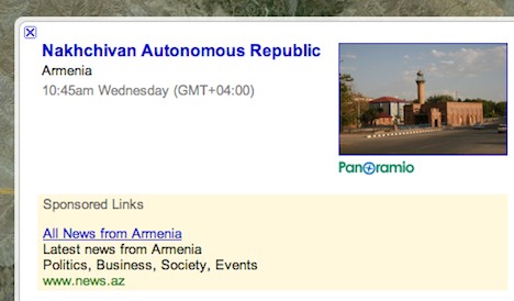
Firstly, on your maps, the territory of Nakhchivan is marked as being Armenian territory. Needless to say, this is absolutely wrong, and the territory of Nakhchivan has never been Armenian. I kindly ask you to correct this mistake.

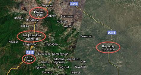
The second mistake concerns the Armenian occupied territories of Azerbaijani Nagorno Karabakh region. We kindly ask you to rename Stepanakert into Khankandi, Mardakert into Agdara and Martuni into Khojavand in your maps as these regions are located in Azerbaijan's territory and therefore cannot have Armenian names. I have to mention that Nagorno (Upper)-Karabakh is an integral part of the Republic of Azerbaijan and the whole world including USA recognises that.

Moreover, it must be noticed that Armenia still occupies 20% of the Azerbaijani territory, Nagorno (Upper)-Karabakh and 7 regions of Azerbaijan beyond Nagorno-Karabakh which are an integral part of Azerbaijan Republic. Azerbaijan has the biggest number of refugees/IDPs per capita in the world. UN Security Council Resolutions 822, 853, 874, 884 on Armenian aggression against Azerbaijan are still ignored by Armenia.

Please take all these into consideration and make necessary changes in Google Maps about the Republic of Azerbaijan.

With best regards and Happy New Year wishes,
Araz N. Imanov
Ministry of Foreign Affairs of the Republic of Azerbaijan
Head of the Information Department of the "AzDipServis" Agency

On the first point, Imanov is absolutely correct. Nakhchivan Autonomous Republic is an exclave that is internationally recognized as part of Azerbaijan, but the link attached to the label for Nakhchivan in Google Earth lists it as being part of Armenia. The same goes for the other labeled cities in the region. This is a clear and simple mistake on the part of Google, and one it should fix.

gearth-nar.jpg

The "second mistake" is not a mistake, however. The primary labels for these places in Google Earth do list the Azeri version of the name. Only as "alternative place names" are the Armenian versions (in Armenian script) listed. This is in keeping with Google's policy (as far as I can discern it) to also provide alternative names of places if they are in wide use locally. In the case of the Nagorno-Karabakh region, those villages listed by Imanov have traditionally had Armenian populations, and those populations themselves have used the Armenian names, even though the territory is internationally recognized as being part of Azerbaijan (albeit occupied and administered by Armenia since the war of 1988-94).

gearth-xank.jpg

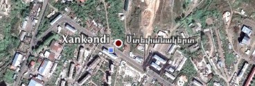
In fact, in Google Earth, only Xankəndi, the capital, also gets an Armenian alternative label ("Ստեփանակերտ", transliterated as "Stepanakert"); the other towns mentioned by Imanov do not. In Google Maps, the Armenian alternative name is also listed for Xankəndi and Xocavənd and a few others, though with the Armenian coming above the Azeri. Perhaps this is what got Imanov's goat? (Perhaps alternative names should go below primary names in Google Maps in the future).

gmaps-nk.jpg

(Worth noting is that Wikipedia tends to prioritize the Armenian version of the places mentioned by Imanov as the primary name: For example, the entry for Xankəndi redirects to wikipedia.org/wiki/Stepanakert, though there both names are used. As a reference, then, Google would appear to be more in tune with the international legal norm than Wikipedia.)

Imanov is correct that in addition to Nagorno-Karabakh a further 9% of Azerbaijan has been occupied by Armenia as a result of the war. Currently, Google Earth does not show the borders of Nagorno-Karabakh, but that is because Google's geographic dataset does not currently include 1st- or 2nd-level administrative borders inside Azerbaijan (or Armenia). I hope such information is added one day, as well as the de facto line of control between Armenia and Azerbaijan. Such a line of control would presumably be colored orange, taking its cue from the line of control between India and Pakistan in Kashmir.

Imanov might conceivably protest at the addition of a line of control inside Azerbaijani territory, but I'd argue that orange lines draw attention to frozen conflicts, and that this can only help Azerbaijan's efforts to publicize the perceived injustices of Armenia's occupation of its territory.

If you want to explore these places in Google Maps or Earth, start here:


View Azerbaijan-Armenia border in a larger map